Hiking Routes and Nature Trails in Suomussalmi
Published: 20.03.2026
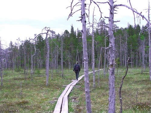
Säynäjäsuo Mire Conservation Area (Photo: Suomussalmen kunta)
Kainuu offers a wide variety of options for hiking and outdoor activities. This article provides an overview of the hiking routes in Suomussalmi. A separate introduction to the trails in the Hossa area will be published next week.
Are you planning to go hiking during the rest days of the Kainuu Orienteering Week? The Suomussalmi and Hossa regions boast magnificent hiking trails featuring diverse terrain and breathtaking landscapes. Some routes are accessible for people with reduced mobility, and equipment rental for assistive devices is available in Vuokatti. In this bulletin, you will find the region's hiking routes and their descriptions. More information and trail maps can be found via the links at the end of this article.
Haverinen–Varisjärvi
- Route length: 30 km
- Distance from Suomussalmi center: 150 m
- Description: The highlight of the Haverinen–Varisjärvi route is the stunning Varisköngäs waterfall. The full loop is approximately 30 km, while the shorter trail circling Lake Varisjärvi is 9.2 km. It is also possible to visit Varisköngäs separately (see the Varisköngäs section). The starting point for the full 30 km loop is located behind Hotel Kiannon Kuohut in the Suomussalmi municipal center.
Jumalissärkät Trail
- Route length: approx. 9.5 km
- Distance from Suomussalmi center: 27 km
- Description: Most of the trail passes through the Jumalissärkät area, a relatively untouched ridge terrain that is part of the Natura 2000 program. Near Lake Vuokkijärvi, the landscape shifts to reflect local forestry with its roads, sapling stands, and felling areas.
Kalmosärkkä – Prehistoric Settlement
- Route length: 2.5 km
- Distance from Suomussalmi center: 65 km
- Description: Kalmosärkkä and its archaeological finds invite you to discover the history and early settlement of Juntusranta. The site is a narrow sandy ridge just over a kilometer long. Kalmosärkkä is a prehistoric dwelling site inhabited as early as 6000 BCE during the Early Stone Age. A marked path leads from the parking area through the forest to the ridge. Before reaching the ridge, you will cross the beautiful Kokkosuo mire via duckboards.
Kurimo Culture Trail
- Route length: 0.3 km and 1.5 km
- Distance from Suomussalmi center: 7 km
- Description: These trails start from the courtyard of Old Kurimo and are designed for the whole family. The Blue Trail (0.3 km) is accessible and features information boards with photos and text detailing the complex history and present day of Kurimo. The slightly more demanding Red Trail (1.5 km) starts from the same location and circles the Kurimo Nature Reserve (6.5 ha).
Children’s Fairytale Trail: Located along the Blue Trail, kids can spot owls, search for geocaches, look for fairies in the trees, and enjoy a nature photography exhibition near the blacksmith’s forge.
Murhisalo Route
- Route length: 9 km
- Distance from Suomussalmi center: 70 km
- Description: The pristine Murhisalo area showcases Kainuu’s old-growth spruce forests and vast mires at their best. It is an ideal day-trip destination for experienced hikers seeking peace and quiet away from the crowds. The area consists of the Lososuo–Saarijärvi mire protection area and surrounding old-growth forests. Murhisalo is also part of the Kalevala Park.
Patokoski Route
- Route length: 2 km
- Distance from Suomussalmi center: 150 m
- Description: This accessible walking route and fishing pier along the Jalonuoma waterway is also known as the Patokoski Route. Located in Ämmänsaari near Hotel Kiannon Kuohut, the trail offers views of the riverbank, the Sonnikallio rock, waterfalls, beard-moss forests, and pine-fringed paths.
Pesiö Hiking Trail
- Route length: 8 km
- Distance from Suomussalmi center: 32 km
- Description: The Pesiö trail is easy to navigate, passing through beautiful ridge and pond landscapes within the Hiidenvaara Nature Reserve. The route features a few steep climbs and short mire sections with duckboards. Highlights include scenic rest stops on capes and a crystal-clear pond. Ancient hunting pits can also be spotted along the way. Note: The length is 8 km one way.
Raate Trails
- Route length: 7 km trail network
- Distance from Suomussalmi center: 22 km
- Description: Located near the Raate Frontier Guard Museum (Raatteen Portti), these trails introduce visitors to the battlegrounds of the Winter War. The network includes informative plaques and three campfire sites. The terrain varies from pine heaths to duckboards over mires and narrow, less-traveled paths.
Saarikylä Nature Trail
- Route length: 3.2 km
- Distance from Suomussalmi center: 64 km
- Description: Interesting information boards and visible traces in the terrain tell the story of the area’s geology and traditional livelihoods, such as tar burning, bog iron, water mills, and the soapstone industry. A unique feature of Saarikylä is "Isokallio," a natural stone "guestbook."
Seitenahveninen
- Route length: 3.7 km
- Distance from Suomussalmi center: 7.5 km
- Description: This trail circles a clear-water forest pond surrounded by mires and pine heaths. Located near the municipal center, it is easily accessible and features two lean-to shelters and a campfire site. A connecting path leads from here to the "Musical Forest" (Soiva Metsä).
Soiva Metsä (The Musical Forest)
- Route length: 2 km
- Distance from Suomussalmi center: 7 km
- Description: The surroundings of Soiva Metsä feature small ponds and deep kettle holes. The ridge at the end of Kaunisniemi offers incredible views over Lake Hietajärvi. Soiva Metsä is a unique collection of large-scale musical instruments built into the forest, which visitors are encouraged to play.
Säynäjäsuo–Matalasuo
- Route length: 10 km
- Distance from Suomussalmi center: 13 km
- Description: This is one of the largest and most significant open mire areas in Kainuu. The landscape is impressive and provides a habitat for wilderness birds. Most of the route consists of two-plank wide duckboards.
- Note: Part of the route is located within the competition area of the Kainuu Orienteering Week 2026, meaning that specific section is subject to training and competition restrictions.
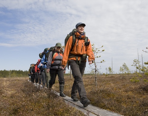
Hikers on the Säynäjäsuo trail (Photo: Suomussalmen kunta)
Varisköngäs
- Route length: 300 m
- Distance from Suomussalmi center: 9 km
- Description: The natural Variskoski, or Varisköngäs, is among the most beautiful waterfalls in Kainuu. Standing approximately 11 meters high, it is a magnificent sight, especially during the spring floods. The falls are accessible via a 300 m marked path from the parking area on Aittokoskentie. The path includes stairs, and the falls can be admired from both a campfire site at the top and a rest area at the bottom.
Viena Route (Vienan reitti)
- Route length: 27 km
- Distance from Suomussalmi center: 47 km
- Description: For thousands of years, the Vuokki route to Viena has been used by peddlers, poem collectors, hunters, and soldiers traveling between Finland and White Sea Karelia (Viena). It is part of an ancient trade route from the Gulf of Bothnia to the White Sea. The Viena Route is a culturally significant path protected by the Antiquities Act.
Further information and trail maps
Explore the routes, maps, and accessibility services in more detail via the following links:
- https://visitsuomussalmi.fi/en/trails-and-nature-attractions/
- https://visitsuomussalmi.fi/en/suomussalmi-trails/
- https://visitsuomussalmi.fi/en/hossa-trails/
- https://www.outdooractive.fi/fi/retkeily-ja-vaellusreitit/suomussalmi/retkeily-ja-vaellus-suomussalmella/127003816/ (only Finnish)
- https://www.outdooractive.fi/fi/offer/vuokatti-sotkamo/para-apuvaelinetoiminta-apuvaelinevuokraus-vuokatti/801582349/#dmdtab=oax-tab1 (only Finnish)
- https://vuokattisport.fi/solia-apuvalinetoiminta-vuokraamo/ (only Finnish)
Head out into nature and enjoy the spectacular trails of Suomussalmi!